
From the first sample to production.
MineGo follows every site through every stage, from mapping through drilling and resource estimates to mining. Engineers report from their phones; supervisors see progress, licence deadlines, finds and equipment for all sites on one overview.
Sign-in by invitation only · Interface in English and Turkish

Every site, every stage.
All sites under exploration in one list: licence, area, end of the licence period, best values and number of drill holes.

Exploration sites
Each site has its licence, its area in hectares, its state from the latest report and its stage, from prospecting to the feasibility study.
- State normal, attention or critical; overdue reports stand out at once
- The best values per element right in the list
- Filter by province, licence status, recommendation and element; search by name, commodity and region
Progress at a glance
Three bars per site: how far the stage has come, how much of the licence period is used and how many metres of the drill programme are drilled.
- Six stages from prospecting to production
- Days left on the licence, the next deadline first
- Drill programme in metres and holes

Every drill hole with its log and assays.
Drilling method, depth, azimuth and dip, geologist and the strip log with rock types and assay values, metre by metre.

The strip log
The log shows the rock layers with the grades beside them, for example copper in per cent and gold in grams per tonne. The best interval is at the top, the metre-by-metre log below.
- Status of every hole, from logged to assayed
- Collar with coordinates, elevation, azimuth and dip
- All holes of a site with planned and reached depth
On the map
A satellite map shows the exact location of each site and the collars of all its drill holes, with the list of holes below.
- Location of the site and of every hole
- Satellite imagery with scale, ready to zoom

Every value from every report.
All assay values from rock and soil samples in one ranking, converted to ppm so that finds can be compared.

Ranking of finds
Filter by element, sample type, province, licence and minimum value; the best value per site or all values, highest first.
- The best finds per element across all sites on the overview
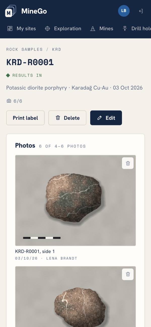
- Rock samples with description and photos
- The recommendation for each site, such as moving to the next stage
Licences and deadlines
The end of every exploration period with the days left, the next one first; licences still being issued are marked.
- Exploration and operating licences with number and stage
- Short deadlines highlighted in colour

Where every rig and every team is right now.
Drill rigs, drones, survey kit and teams on one map: where they are now, since when and where they were before.

Deployment on the map
Every piece of equipment has its status (working, maintenance, standby or in transit) and its location. Teams are in the field or in transit, with their head count.
- Rigs, equipment, teams in the field and people counted
- Add new equipment and teams directly
Reports straight from the phone.
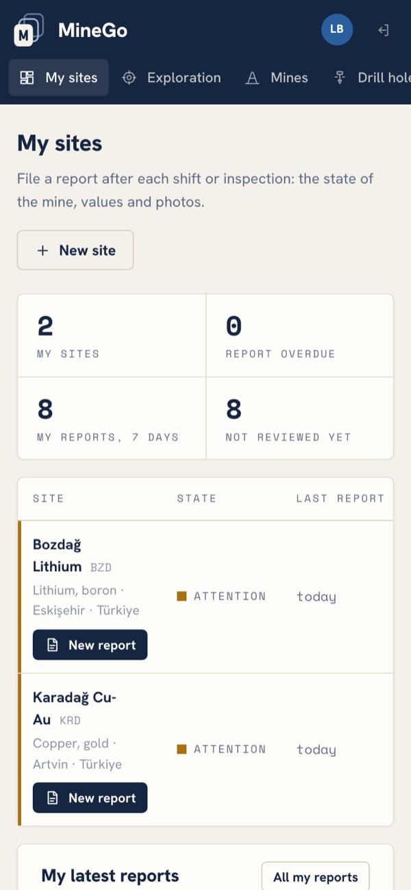
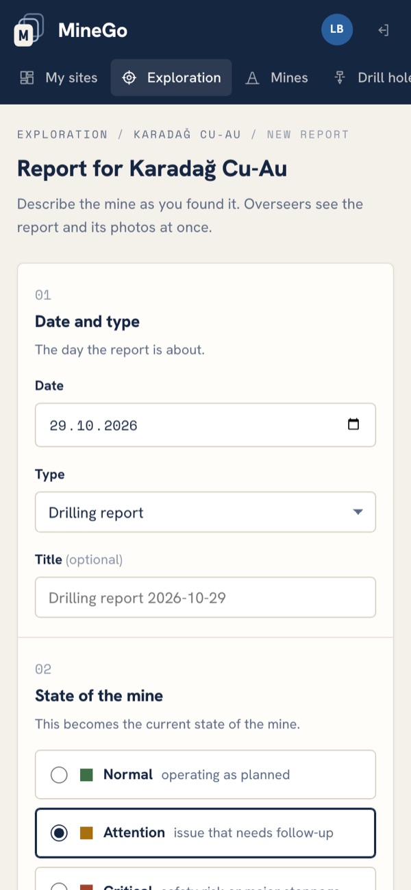
For engineers on site: register mines, report after every shift or inspection and attach photos of the current state.
Mines and reports
Every mine has a name, commodity, type (open pit, underground, quarry), stage, region, GPS coordinates and a responsible engineer. A report is a numbered sheet: 01 Date and type, 02 State of the mine (Normal, Attention or Critical), 03 Findings, 04 Measured values, 05 Photos.
- Report types: daily, weekly, inspection, incident or maintenance
- Measured values such as ore mined, waste moved, ore grade, methane, water inflow, equipment availability and workers on site, plus custom values with a unit
- Record rock samples with a photo straight from the phone
- Photos straight from the camera; the page scales them down before uploading
- Engineers can edit their own reports until an overseer has reviewed them
All sites and mines on one overview.
A totals strip counts the mines, the critical ones, those needing attention, overdue reports and reports not yet reviewed. Below it is the state register of all open mines, most urgent first, and the ore mined over the last 30 days.

Every mine in detail
The current state from the latest report, a history for every measured value, all reports and the mine's photos.
- A state register with state, stage, latest report, the person responsible and ore mined
- Open matters and the latest reports on the overview
- A mine without a report for seven days counts as overdue
Reviewing reports
Overseers open any report and mark it as reviewed, with a note back to the engineer if they like; the engineer sees it on their start page.
- The report's values, issues and photos on one page
- Invite people, send reset links, change roles and deactivate accounts

Everything in writing, searchable.
Reports, assay certificates, permits, studies and drill logs belong to the site; the text inside PDF, Word, Excel and CSV files is searchable.

Documents and search
Filter by site and type. One search box finds sites, drill holes, samples, reports and the text inside documents.
- Upload on the computer, sorted by date
- One search box for everything
Secure sign-in, by invitation only.
An overseer adds people; they set their password through a one-time link that is valid for seven days.
Engineers report from the field; overseers see every mine and review the reports.
On computers and phones, nothing to install.
MineGo runs on our own server in Germany, next to Etra Atlas.
Access to MineGo.
Your overseer gives you access. MineGo for your company? Write to us.